


A 500-year-old map used by Columbus reveals its secrets
Newly uncovered text opens a time capsule of one of history’s most influential maps.
This 1491 map is the best surviving map of the world as Christopher Columbus knew it as he made his first voyage across the Atlantic. In fact, Columbus likely used a copy of it in planning his journey.
The map, created by the German cartographer Henricus Martellus, was originally covered with dozens of legends and bits of descriptive text, all in Latin. Most of it has faded over the centuries.
But now researchers have used modern technology to uncover much of this previously illegible text. In the process, they’ve discovered new clues about the sources Martellus used to make his map and confirmed the huge influence it had on later maps, including a famous 1507 map by Martin Waldseemuller that was the first to use the name “America.”
MARTELLUS AND COLUMBUS
Contrary to popular myth, 15th-century Europeans did not believe that Columbus would sail off the edge of a flat Earth, says Chet Van Duzer, the map scholar who led the study. But their understanding of the world was quite different from ours, and Martellus’s map reflects that.
Its depiction of Europe and the Mediterranean Sea is more or less accurate, or at least recognizable. But southern Africa is oddly shaped like a boot with its toe pointing to the east, and Asia is also twisted out of shape. The large island in the South Pacific roughly where Australia can actually be found must have been a lucky guess, Van Duzer says, as Europeans wouldn’t discover that continent for another century. Martellus filled the southern Pacific Ocean with imaginary islands, apparently sharing the common mapmakers’ aversion to empty spaces.
Another quirk of Martellus’s geography helps tie his map to Columbus’s journey: the orientation of Japan. At the time the map was created, Europeans knew Japan existed, but knew very little about its geography. Marco Polo’s journals, the best available source of information about East Asia at the time, had nothing to say about the island’s orientation.
Martellus’s map shows it running north-south. Correct, but almost certainly another lucky guess says Van Duzer, as no other known map of the time shows Japan unambiguously oriented this way. Columbus’s son Ferdinand later wrote that his father believed Japan to be oriented north-south, indicating that he very likely used Martellus’s map as a reference.
When Columbus made landfall in the West Indies on October 12, 1492, he began looking for Japan, still believing that he’d achieved his goal of finding a route to Asia. He was likely convinced Japan must be near because he’d travelled roughly the same distance that Martellus’s map suggests lay between Europe and Japan, Van Duzer argues in a new book detailing his findings.
Van Duzer says it’s reasonable to speculate that as Columbus sailed down the coast of Central and South America on later voyages, he pictured himself sailing down the coast of Asia as depicted on Martellus’s map.


RESTORING A TIME CAPSULE
The map is roughly 3.5 by 6 feet. Such a large map would have been a luxury object, likely commissioned by a member of the nobility, but there’s no shield or dedication to indicate who that might have been. It was donated anonymously to Yale University in 1962 and remains in the university’s Beinecke Rare Book & Manuscript Library.
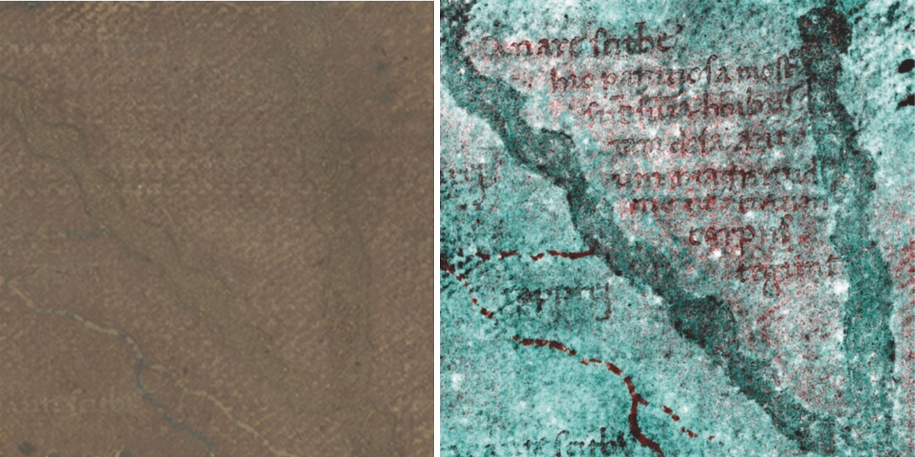
Over time, much of the text had faded to almost perfectly match the background, making it impossible to read. But in 2014 Van Duzer won a grant from the National Endowment for the Humanities that allowed him and a team of collaborators to use a technique called multispectral imaging to try to uncover the hidden text.
The method involved taking many hundreds of photographs of the map with different wavelengths of light and processing the images to find the combination of wavelengths that best improves legibility on each part of the map (you can play around with an interactive map created by one of Van Duzer’s colleagues here).
Many of the map legends describe the regions of the world and their inhabitants. “Here are found the Hippopodes: they have a human form but the feet of horses,” reads one previously illegible text over Central Asia. Another describes “monsters similar to humans whose ears are so large that they can cover their whole body.” Many of these fantastical creatures can be traced to texts written by the ancient Greeks.
The most surprising revelation, however, was in the interior of Africa, Van Duzer says. Martellus included many details and place names that appear to trace back to an Ethiopian delegation that visited Florence in 1441. Van Duzer says he knows of no other 15th-century European map that has this much information about the geography of Africa, let alone information derived from native Africans instead of European explorers. “I was blown away,” he says.
The imaging also strengthens the case that Martellus’s map was a major source for two even more famous cartographic objects: the oldest surviving terrestrial globe, created by Martin Behaim in 1492, and Martin Waldseemuller’s 1507 world map, the first to apply the label “America” to the continents of the western hemisphere. (The Library of Congress purchased Waldseemuller’s map for a record $10 million in 2003.)
Waldseemuller liberally copied text from Martellus, Van Duzer found after comparing the two maps. The practice was common in those days—in fact, Martellus himself apparently copied the sea monsters on his map from an encyclopedia published in 1491, an observation that helps date the map.
Despite their commonalities, the maps by Martellus and Waldseemuller have one glaring difference. Martellus depicts Europe and Africa nearly at the left edge of his map, with only water beyond. Waldseemuller’s map extends further to the west and depicts new lands on the other side of the Atlantic. Only 16 years had passed between the making of the two maps, but the world had changed forever.
Greg Miller and Betsy Mason are authors of the forthcoming illustrated book from National Geographic, All Over the Map. Follow the blog on Twitter and Instagram.
Related Topics
You May Also Like


Go Further
Animals
- Fireflies are nature’s light show at this West Virginia state parkFireflies are nature’s light show at this West Virginia state park
- These are the weird reasons octopuses change shape and colorThese are the weird reasons octopuses change shape and color
- Why young scientists want you to care about 'scary' speciesWhy young scientists want you to care about 'scary' species
- What rising temperatures in the Gulf of Maine mean for wildlifeWhat rising temperatures in the Gulf of Maine mean for wildlife
- He’s called ‘omacha,’ a dolphin that transforms into a man. Why?He’s called ‘omacha,’ a dolphin that transforms into a man. Why?
Environment
- What rising temperatures in the Gulf of Maine mean for wildlifeWhat rising temperatures in the Gulf of Maine mean for wildlife
- He’s called ‘omacha,’ a dolphin that transforms into a man. Why?He’s called ‘omacha,’ a dolphin that transforms into a man. Why?
- The northernmost flower living at the top of the worldThe northernmost flower living at the top of the world
- This beautiful floating flower is wreaking havoc on NigeriaThis beautiful floating flower is wreaking havoc on Nigeria
- What the Aral Sea might teach us about life after disasterWhat the Aral Sea might teach us about life after disaster
History & Culture
- Scientists find evidence of ancient waterway beside Egypt’s pyramidsScientists find evidence of ancient waterway beside Egypt’s pyramids
- This thriving society vanished into thin air. What happened?This thriving society vanished into thin air. What happened?
Science
- Why pickleball is so good for your body and your mindWhy pickleball is so good for your body and your mind
- Extreme heat can be deadly – here’s how to know if you’re at riskExtreme heat can be deadly – here’s how to know if you’re at risk
- Why dopamine drives you to do hard things—even without a rewardWhy dopamine drives you to do hard things—even without a reward
- What will astronauts use to drive across the Moon?What will astronauts use to drive across the Moon?
- Oral contraceptives may help lower the risk of sports injuriesOral contraceptives may help lower the risk of sports injuries
- How stressed are you? Answer these 10 questions to find out.
- Science
How stressed are you? Answer these 10 questions to find out.
Travel
- A guide to Philadelphia, the US city stepping out of NYC's shadowA guide to Philadelphia, the US city stepping out of NYC's shadow
- How to make perfect pierogi, Poland's famous dumplingsHow to make perfect pierogi, Poland's famous dumplings
- The best long-distance Alpine hike you've never heard ofThe best long-distance Alpine hike you've never heard of
- Fireflies are nature’s light show at this West Virginia state parkFireflies are nature’s light show at this West Virginia state park
- How to explore the highlights of Italy's dazzling Lake ComoHow to explore the highlights of Italy's dazzling Lake Como
- Going on a cruise? Here’s how to stay healthy onboardGoing on a cruise? Here’s how to stay healthy onboard
